Introduction
A new, hopeful paradigm is emerging in humanity’s contract with the land. Global cooperation to deploy tech-based solutions can realize visions of abundant, multi-use landscapes benefitting all life.
What is desertification
Consequences
How technology & agriculture can battle desertification
Technology: Satellites
Technology: Sensors
Technology: Connectivity
Projects that fight desertification
What is Desertification
The endless advance of barren land. Desertification refers to the process through which previously productive land becomes barren desert due to a combination of natural and human factors. Climate shifts like drought and human activities like deforestation, intensive farming and overgrazing strip away fertile topsoil.
A feedback loop results where loss of vegetation decreases rainfall infiltration, worsening moisture deficiency. Remaining plant life struggles to retain a precarious foothold. Without intervention,Beautiful ecosystems become bleak wastelands devoid of life-giving nutrients.
Over 1 billion hectares of land globally are currently degraded. Each year over 12 million additional hectares become barren. Desertification intensifies climate change through carbon and methane emissions even while exacerbating water scarcity, flooding, biodiversity collapse and communal conflicts.
Cascading Consequences of Accelerating Desertification
Runaway desertification sets off cascading crises across ecological, political and socioeconomic systems. Climate change accelerates while resilience declines precisely when mitigating capacity is most desperately needed.
Land degradation intensifies competition for depleted natural resources like water, amplifies food insecurity and supercharges displacement conflicts. By 2045, an estimated 135 million climate refugees will be set adrift as expanding deserts swallow habitable zones.
Restorative machines cannot single-handedly rectify the complex chaos spawned by desertification. Remedy requires a fundamental shift toward conservation, cooperation and long-term thinking in matters of land stewardship. However technology can empower communities to enact this difficult metamorphosis.
Summary: Ways Agriculture & Technology Can Combat Desertification
-
Adopt sustainable practices: crop rotation, no-till, agroforestry, organic farming to restore soil health
-
Leverage precision technology like satellite imaging, sensors, AI to optimize water/nutrient use
-
Implement moisture sensor systems to enable need-based, efficient irrigation
-
Develop heat/drought resistant GMO crops while ensuring ecological balance
-
Apply regenerative techniques to replenish soil biodiversity and fertility organically
-
Incorporate indigenous land management wisdom with modern science/tech
-
Craft supportive policies and investments to scale sustainable agriculture
-
Build global collaboration networks to accelerate technology transfer and adoption
Satellites: The “Eyes in the Sky” Tracking Land Health
Earth observation satellites monitor environmental indicators like soil composition, moisture levels and plant health at unprecedented scale and speed. Vegetation indices reveal drought patterns to target water deliveries precisely. Methane maps uncover unseen emissions sources to stem. Read more about what NDVI mapping & imagery is.
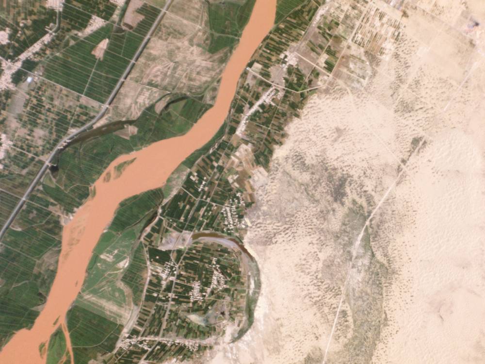
Desertification Control Project Ningxia China: Planet Labs satellite image
Public agencies like NASA and ESA make their continuous streams of geospatial analytics data freely available to conservation groups. Meanwhile, private satellites like Planet Labs generate additional real-time HD visual feeds. AI models integrate these variegated sources into actionable terrain insights.
In Tanzania, satellite analysis guides restoration of 65,000 hectares of degraded grasslands. In the EU, Sentinel-2 images monitor blooming crops to anticipate yield spikes and prevent food waste. Space assets usher in planetary-scale land stewardship transcending borders.
Sensors Enable Hyperlocal Control Over Soil & Water
Moisture sensors integrated into intelligently controlled drip irrigation rigs transport exact water volumes directly to crop root zones with no loss to evaporation or runoff. Across the Middle East, sodden deserts morph into orchards and vegetable gardens using this surgically precise micro-irrigation technique.
The image below shows regional desertification areas:
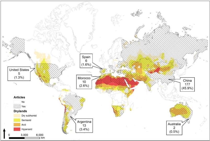
Remote sensing worldwide. “The use of remote sensing for desertification studies”
Remote sensing worldwide. “The use of remote sensing for desertification studies”
Underground sensor arrays monitor soil chemistry and transmit data to the cloud. AI algorithms review profiles of macronutrients like nitrogen & phosphorus to recommend optimal organic fertilizer blends. Indian agritech startups provide smallholding farmers simplified soil testing kits to implement this precision agriculture.
IoT connectivity empowers decentralized cooperation by linking contested transboundary water resources to shared cloud analytics dashboards. Switzerland assists Italian farmers in optimizing allocation of Lake Lugano. USA and Mexico coordinate over Colorado River usage.
Empowering Communities with Connectivity & Alternatives
Bottom-up, community-led conservation movements exponentially amplify impact when augmented by global communications infrastructure, technical resources and alternative income streams. Ecological restoration interweaves with poverty alleviation and conflict mitigation.
Mobile phones connect indigenous farmers with scientists. Health information protects families while enabling education continuity. Affordable solar kilowatt networks energize village entrepreneurship. Donor grants trial production of drought-resilient secondary crops like quinoa, amaranth, sorghum.
Online organic agriculture course certificates authorize higher prices at urban markets. Apiculture cooperatives market rare honeys abroad using e-commerce platforms. Digital tools expand possibilities, reshaping livelihoods around sustainability to heal both communities and ecosystems symbiotically.